Currently browsing category

Graphics / Data Visualization / Maps

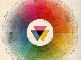
History of color wheels

    The 2-part series The Wonderful Color Wheel: Part 1 and Part 2  takes you from the 18th c. enlightenment to the present, with great examples.  At the end of the second part there are references to The Creation of Color in Eighteenth-Century Europe and History of the Color Wheel.  This post …

U.S. geothermal database

  National Geothermal Data System (NGDS) from the U.S. Dept of Energy allows you to “search for data from 50 state geological surveys and a number of geothermal research centers and build mashups of maps or search through thousands of scanned reports.”  Read more about it on Arizona Geology.  Via ResearchBuzz.