
Water, water everywhere – designing for floods
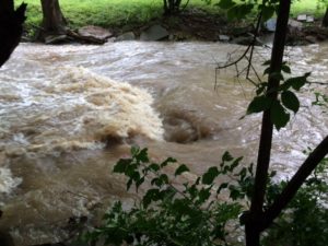

This little creek in south St. Louis County is part of the vast watershed of the Mississippi and Missouri Rivers (click here for an animated map of the entire watershed). The creek is normally a lazy trickle but with a bit of rain it rises rapidly. In these photos it’s just getting started. After an hour of heavy rain it overflows its banks and makes a streaming lake of the yards all along its low bank. This water is traveling fast. It roars, almost like a train passing. It’s relentless, sweeping away everything in its path and steadily eroding the creek banks. Basements take in water. Sump pumps work overtime. Some people put in drain tile in an attempt to prevent basement flooding, others make sure everything in the basement is raised enough to keep most things dry.
A rising creek is, however, a minuscule example of the destructive power and inconvenience of flooding. Serious and catastrophic flooding takes out homes, farms, topsoil, bridges, roadways, even whole communities and, too often, lives.
2019 has been setting rainfall records all over the U.S. Cities and towns along the Mississippi and Missouri Rivers have had to re-think flood mitigation plans, raising the long-standing debate between using levees, dams, and flood walls to hold flood waters away from property and crop land or reclaiming often over-built floodplains and wetlands to reduce damage by allowing flood waters to spread out and slow down. For more about that debate check here and here.
One website that helps communities decide how to accommodate the natural behavior of flood waters while minimizing damage is Naturally Resilient Communities (NDC).
We’ve created this guide of nature-based solutions and included case studies of successful projects from across the country to help communities learn more and identify which nature-based solutions might work for them.
The clearly organized website leads you through choices, starting with hazard type – coastal flooding & erosion, river flooding & erosion, or urban stormwater flooding – then U.S. region, community type, scale, and cost to arrive at possible solutions, with case studies. There’s a page on sources of funding for nature-based solutions, and a page of additional resources and contacts for planners.
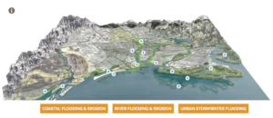
Scroll down on the homepage for an interactive graphic that illustrates mitigation strategies included in the solutions and case studies. For each solution you’ll find details on hazard mitigation, threats, co-benefits, and additional resources. Each case study provides you with project details, the challenge, overview/history, the solution, and benefits as well as photos.
NDC is an interesting partnership of a number of entities: American Planning Association, American Society of Civil Engineers, Association of State Floodplain Managers, ASCE’s Environmental & Water Resources Institute, National Association of Counties, The Nature Conservancy, and Sasaki. Credit for the website and excellent graphic design goes to Sasaki.